Sie nennen es das Auge der Sahara. Vierzig Kilometer Durchmesser, konzentrische Ringe aus rotem und schwarzem Stein, sichtbar nur aus dem Weltraum. Und vielleicht — nur vielleicht — ist es alles, was von Atlantis übrig blieb.
*Der Rauch kräuselt sich. Draußen pfeift der Wüstenwind. Manche Geschichten beginnen mit einer Frage. Diese beginnt mit einer Lüge.*
DIE OFFIZIELLE VERSION
Die akademische Archäologie erzählt es so: Atlantis war nie real. Plato erfand es als politische Allegorie — eine Warnung an Athen vor der mazedonischen Expansion. Nichts weiter als antike Propaganda.
Fall geschlossen. Akten zu. Weitergehen, hier gibt es nichts zu sehen.
*Nur dass die Akten Löcher haben.*
PLATONS PRÄZISION
Für eine Erfindung liefert Plato erstaunlich genaue Details. In seinen Dialogen Timaeus und Critias beschreibt er:
Konzentrische Wasserringe um eine zentrale Insel. Roten und schwarzen Stein. Einen Durchmesser von 127 Stadien — umgerechnet 23,5 Kilometer. Berge im Norden, flache Ebenen rundherum. Einen Kanal zum Meer nach Süden. Salziges Grundwasser überall — außer im Zentrum.
Er beruft sich auf ägyptische Priester als Quelle. Datiert die Zerstörung auf 9.000 Jahre vor seiner Zeit.
*Viel Aufwand für eine Fabel.*
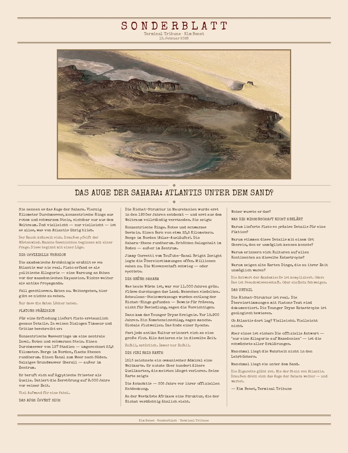
DAS AUGE ÖFFNET SICH
Die Richat-Struktur in Mauretanien wurde erst in den 1930er Jahren entdeckt — und erst aus dem Weltraum vollständig verstanden. Sie zeigt:
Konzentrische Ringe. Rotes und schwarzes Gestein. Einen Kern von etwa 23,5 Kilometern. Berge im Norden (Atlas-Ausläufer). Die Sahara-Ebene rundherum. Erhöhten Salzgehalt im Boden — außer im Zentrum.
Jimmy Corsetti vom YouTube-Kanal Bright Insight legte die Übereinstimmungen offen. Millionen sahen zu. Die Wissenschaft schwieg — oder spottete.
DIE GRÜNE SAHARA
Was heute Wüste ist, war vor 11.000 Jahren grün. Flüsse durchzogen das Land. Menschen siedelten. Acheulean-Steinwerkzeuge wurden entlang der Richat-Ringe gefunden — Beweis für Präsenz, nicht für Besiedlung, sagen die Vorsichtigen.
Dann kam das Younger Dryas Ereignis. Vor 12.900 Jahren. Ein Kometeneinschlag, sagen manche. Globale Flutwellen. Das Ende einer Epoche.
Fast jede antike Kultur erinnert sich an eine große Flut. Alle datieren sie in dieselbe Zeit.
*Zufall, natürlich. Immer nur Zufall.*
DIE PIRI REIS KARTE
1513 zeichnete ein osmanischer Admiral eine Weltkarte. Er nutzte über hundert ältere Quellkarten, die meisten längst verloren. Seine Karte zeigt:
Die Antarktis — 305 Jahre vor ihrer offiziellen Entdeckung.
An der Westküste Afrikas: eine Struktur, die der Richat verdächtig ähnlich sieht.
Woher wusste er das?
WAS DIE WISSENSCHAFT NICHT ERKLÄRT
Warum lieferte Plato so präzise Details für eine Fiktion?
Warum stimmen diese Details mit einem Ort überein, den er unmöglich kennen konnte?
Warum erinnern sich Kulturen auf allen Kontinenten an dieselbe Katastrophe?
Warum zeigen alte Karten Dinge, die zu ihrer Zeit unmöglich waren?
*Die Antwort der Akademie: Es ist kompliziert. Oder: Das ist Pseudowissenschaft. Oder einfach: Schweigen.*
DAS URTEIL
Die Richat-Struktur ist real. Die Übereinstimmungen mit Platons Text sind dokumentiert. Die Younger Dryas Katastrophe ist geologisch bewiesen.
Ob Atlantis dort lag? Vielleicht. Vielleicht nicht.
Aber eines ist sicher: Die offizielle Antwort — "nur eine Allegorie auf Mazedonien" — ist die schwächste aller Erklärungen.
Manchmal liegt die Wahrheit nicht in den Lehrbüchern.
Manchmal liegt sie unter dem Sand.
*Die Zigarette glüht rot. Wie der Stein von Atlantis. Draußen dreht sich das Auge der Sahara weiter — und wartet.*
— Kim Benet, Terminal Tribune
They call it the Eye of the Sahara. Forty kilometers in diameter, concentric rings of red and black stone, visible only from space. And perhaps — just perhaps — it's all that remained of Atlantis.
*The smoke curls. Outside, the desert wind whistles. Some stories begin with a question. This one begins with a lie.*
THE OFFICIAL VERSION
===
Academic archaeology tells it this way: Atlantis was never real. Plato invented it as a political allegory — a warning to Athens about Macedonian expansion. Nothing more than ancient propaganda.
Case closed. Files shut. Move along, nothing to see here.
*Except that the files have holes.*
PLATO'S PRECISION
===
For an invention, Plato provides astonishingly accurate details. In his dialogues Timaeus and Critias, he describes:
- Concentric rings of water around a central island.
- Red and black stone.
- A diameter of 127 stadia — equivalent to 23.5 kilometers.
- Mountains to the north, flat plains all around.
- A canal to the sea to the south.
- Salty groundwater everywhere — except in the center.
He cites Egyptian priests as his source. Dates the destruction to 9,000 years before his time.
*A lot of effort for a fable.*
THE EYE OPENS
===
The Richat Structure in Mauritania was only discovered in the 1930s — and only fully understood from space. It shows:
- Concentric rings.
- Red and black rock.
- A core of about 23.5 kilometers.
- Mountains to the north (outskirts of the Atlas).
- The Sahara plain all around.
- Elevated salt content in the soil — except in the center.
Jimmy Corsetti from the YouTube channel Bright Insight revealed the correspondences. Millions watched. Science remained silent — or mocked.
THE GREEN SAHARA
===
What is desert today was green 11,000 years ago. Rivers crossed the land. People settled. Acheulean stone tools were found along the Richat rings — proof of presence, not settlement, the cautious say.
Then came the Younger Dryas event. 12,900 years ago. A comet impact, some say. Global tidal waves. The end of an era.
Almost every ancient culture remembers a great flood. All date it to the same time.
*Coincidence, of course. Always just coincidence.*
THE PIRI REIS MAP
===
In 1513, an Ottoman admiral drew a world map. He used over a hundred older source maps, most long lost. His map shows:
- Antarctica — 305 years before its official discovery.
- On the west coast of Africa: a structure that looks suspiciously like the Richat.
Where did he know that from?
WHAT SCIENCE DOES NOT EXPLAIN
===
Why did Plato provide such precise details for a fiction?
Why do these details match a place he could not possibly have known?
Why do cultures on all continents remember the same catastrophe?
Why do old maps show things that were impossible in their time?
*The academy's answer: It's complicated. Or: That's pseudoscience. Or simply: Silence.*
THE VERDICT
===
The Richat Structure is real. The correspondences with Plato's text are documented. The Younger Dryas catastrophe is geologically proven.
Whether Atlantis lay there? Maybe. Maybe not.
But one thing is certain: the official answer — "just an allegory for Macedonia" — is the weakest of all explanations.
Sometimes the truth is not in the textbooks.
Sometimes it lies beneath the sand.
*The cigarette glows red. Like the stone of Atlantis. Outside, the Eye of the Sahara continues to turn — and wait.*
— Kim Benet, Terminal Tribune